The fishing community uses traditional methods of locating fishing grounds using Bird Congregation, Colour of water, Bubbles breaking on sea surface, Waves and currents, and even smell. These obviously are not accurate
Moreover, there is No Telecom connectivity at deep sea.
Advisories on Potential Fishing Zone using Satellite Communications
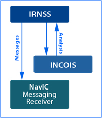
Indian National Centre for Ocean Information Services (INCOIS) under Ministry of Earth Sciences (MoES) provides ocean information services for the benefit of various user communities in the country. The services are more fruitfully utilized when the advisories reaches the end user in timely manner and in user readable format. INCOIS has adopted the state-of-the-art technologies and tools available in the country for the timely dissemination of Ocean Information and Advisory Services that includes
- Potential Fishing Zone (PFZ) advisories
- Ocean State Forecast (OSF)
- High Wave Alerts and Tsunami early warnings
These advisories and Alerts cannot reach the fishermen as there is no Telecom Connectivity at Deep Sea, and Satellite Phones are exorbitantly priced.
The Advisories would reach the fishermen through the Duro Messaging System from Skycube.
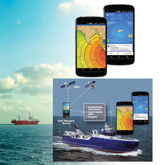
The NavIC Mobile application on Android Mobile Phones would work totally offline and display areas for potential fishing zones. The App would also provide the facility for waypoint navigation from the fisher’s current position to the selected area of potential fishing. Through INCOIS, the App would also generate Emergency Alert Messages for extreme or adverse weather conditions – cyclones, tidal waves, high tides, Tsunamis etc.
The NavIC application would provide:
- Any emergency alert would be easily available to the fishermen, as a result a lot of lives would be saved
- Facility to receive emergency messages – high tide wave, cyclone, etc. from INCOIS
- Way point Navigation from current location to Selected Potential Fishing Zone
- Alert messages on nearing or crossing the International borders or nearing or entering foreign country borders
Technology for Disaster Management
Natural Disasters like floods, cyclones are not very uncommon in India. Odisha Government has done tremendous work in Disaster Management and saving lives.
During such disasters, communication becomes a big challenge as the Telecom Networks are unreliable and Radio Messaging work only in a very limited distance. Satellite phone are extremely costly.
Duro Messaging Receivers from Skycube are the tools that would come handy during the emergency situations where disaster relief is urgent and important, as there can be Satellite based communication and messages to remote areas and each up to the Village Panchayat level. Weather advisories can be transmitted through this channel, and also potential hazards due to inclement climatic changes can be communicated too.
In addition, various remote sensing based modeling to estimate storm water surge estimation is continuously disseminated, which can now reach to each village through Duro Messaging Receivers.


